Buried Infrastructure
A New Generation Sensor for Buried Infrastructure Planning and Design
LandRay sensor technology makes possible the development of numerous high need applications. Three proprietary system functions combine to create LandRay's new generation sensor technology.
- A proprietary construct for multidirectional radiation of Continuous Wave Digital Linear Frequency Modulated (CW-DLFM) signal
- A novel antenna silhouette enabling recovery of return signal of low-to-high amplitude range in “point cloud” density
- A novel raw data processing suite
Currently, transmission of waveform through signal-resistant (”signal attenuating”) media such as clay-laden soils severely limit the utility of non-invasive ground penetrating tools (“Ground Penetrating Radars”).
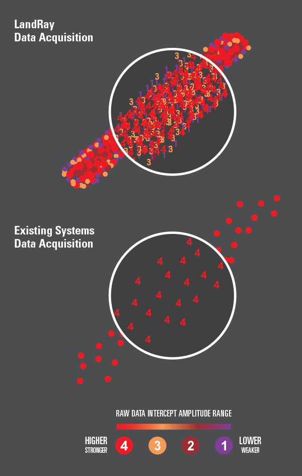
Dynamic range is central to the acquisition of buried target object dimensioning and location data. It is paramount to all other functional features contributing to the data gathering capability of ground penetrating systems.
Measured in decibels (DB), dynamic range is the sole determinant of device sensitivity. Dynamic range refers to the amplitude range/strength of target object “reflected signal” that an RF waveform generator can detect: as dynamic range increases, the acquisition of raw target object data increases.
Signal Recovery
Large Dynamic Range Enables Recovery of Signal with a Very Low-to High Range of Amplitude, Producing Unparalleled Point Cloud Density

Global Value:
Development of What Users Need
The underground construction market is comprised of special application users who, as a first consideration, want to reliably identify and document “what is down there” and “where it is.” Accurate documentation of underground conditions is the base layer of reliable site plan work.
The Performance Shortcomings of Today’s Products
The utility of virtually all commercially available non-invasive detection products is limited by their unreliable data gathering capability. LandRay findings indicate the following:
- User adoption of ground penetrating radar for below-ground imaging and mapping has been modest because of its inability to assure the timely production of reliable images of targeted objects. Researchers summarize the problem as a failure to acquire usable dimension data.
- No output and unreliable output are the result of high rates of signal attenuation. The result is unsatisfactory signal data collection.
- Slow data processing and the cost of follow-on interpretive work aggravate the problem.
According to the National Soil Survey Center, National Resources Conservation Service,* “a common concern of GPR service providers is whether or not GPR will be able to achieve the desired depth of penetration in the soils of a project area. In many soils, high rates of signal attenuation severely restrict penetration depth and limit the suitability of GPR for applications. In saline and sodic soils, where penetration depths are often less that 10 inches (Daniels, 2004) GPR is unsuited to most applications. In wet clays, where penetration depths are typically less 40 inches (Doolittle et al, 2002), GPR has very low solution potential for most applications. However, GPR is highly suited to most applications in dry sands and gravels, where penetration depths can exceed 160 feet with low frequency antennas (Smith and Jol, 1995).” (Source, NSSC, NRCS page 5) LandRay Technology management estimates that conventional impulse radar GPR products can operate reliably in only 30% of the soils in the continental United States